
Chancellorsville, Battle of›Battle of Chancellorsville, Virginia, May 2nd & 3rd 1863.
- Publication:
- US, Civil War Maps, 1861-1865
- Region:
- Virginia
- Location:
- Chancellorsville, Battle of
- Title:
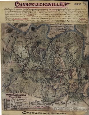
- Battle of Chancellorsville, Virginia, May 2nd & 3rd 1863.
- Source:
- Virginia Historical Society
- Description:
- This large detailed map shows the area defined by the Rapidan and Rappahannock rivers and Wilderness Run and indicates the locations of various units over the course of the middle two days of fighting.
- Conflict Period:
- US Civil War
View the actual high resolution document.
About US, Civil War Maps, 1861-1865
Maps, charts, and atlases depicting battles, troop positions and movements, engagements, and fortifications during the Civil War, 1861-1865.
Source Information
Fold3, US, Civil War Maps, 1861-1865 (https://www.fold3.com/document/279589138/battle-of-chancellorsville-virginia-may-2nd-3rd-1863-page-1-us-civil-war-maps-1861-1865 : accessed Apr 26, 2024), database and images, https://www.fold3.com/document/279589138/battle-of-chancellorsville-virginia-may-2nd-3rd-1863-page-1-us-civil-war-maps-1861-1865
- Publication Title
- US, Civil War Maps, 1861-1865
- Total Records
- 1,933Complete: 100%
- Content Source
Fold3
- Published on Fold3
- May 20, 2010
- Last Updated
- November 18, 2011
Related Records
Related Publications
- US, The Horse Soldier Civil War Collection of Military Artifacts, 1861-1865
- Civil War Stories
- US, General Court Martial of Gen. George A. Custer, 1867
- US, Subject File of the Confederate States Navy, 1861-1865
- US, Official Records of the Union and Confederate Navies, 1861-1865
- US, Maine, Burial Records of the Togus National Home for Disabled Veterans, 1874-1938
- US, Weekly Returns of Enlistments at Naval Rendezvous ("Enlistment Rendezvous") Jan. 6, 1855-Aug. 8, 1891
- US, New Hampshire, Revolutionary War Records, 1675-1835
- US, Washington State Military Records, 1855-1950
- US, Adjutant General Military Records, 1631-1976
- See all publications