
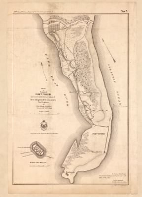
Fort Fisher›Sketch of vicinity of Fort Fisher : surveyed under the direction of Brvt. Brig. Gen. C. B. Comstock, Chief Engineer / by Otto Julian Schultze, Private 15th N.Y.V. Eng.
- Publication:
- US, Civil War Maps, 1861-1865
- Region:
- North Carolina
- Location:
- Fort Fisher
- Title:
- Sketch of vicinity of Fort Fisher : surveyed under the direction of Brvt. Brig. Gen. C. B. Comstock, Chief Engineer / by Otto Julian Schultze, Private 15th N.Y.V. Eng.
- Source:
- Library of Congress Geography and Map Division Washington
- Description:
- Surveyed under the direction of Brvt. Brig. Gen. C. B. Comstock, Chief Engineer / by Otto Julian Schultze, Private 15th N.Y.V. Eng.
- Conflict Period:
- US Civil War
View the actual high resolution document.
About US, Civil War Maps, 1861-1865
Maps, charts, and atlases depicting battles, troop positions and movements, engagements, and fortifications during the Civil War, 1861-1865.
Source Information
Fold3, US, Civil War Maps, 1861-1865 (https://www.fold3.com/document/260558720/sketch-of-vicinity-of-fort-fisher-surveyed-under-the-direction-of-brvt-brig-gen-c-b-comstock-chief-e : accessed May 5, 2024), database and images, https://www.fold3.com/document/260558720/sketch-of-vicinity-of-fort-fisher-surveyed-under-the-direction-of-brvt-brig-gen-c-b-comstock-chief-e
- Publication Title
- US, Civil War Maps, 1861-1865
- Total Records
- 1,933Complete: 100%
- Content Source
Fold3
- Published on Fold3
- May 20, 2010
- Last Updated
- November 18, 2011
Related Records
Related Publications
- US, The Horse Soldier Civil War Collection of Military Artifacts, 1861-1865
- Civil War Stories
- US, General Court Martial of Gen. George A. Custer, 1867
- US, Subject File of the Confederate States Navy, 1861-1865
- US, Official Records of the Union and Confederate Navies, 1861-1865
- US, Maine, Burial Records of the Togus National Home for Disabled Veterans, 1874-1938
- US, Weekly Returns of Enlistments at Naval Rendezvous ("Enlistment Rendezvous") Jan. 6, 1855-Aug. 8, 1891
- US, New Hampshire, Revolutionary War Records, 1675-1835
- US, Washington State Military Records, 1855-1950
- US, Adjutant General Military Records, 1631-1976
- See all publications